Another Phyllite Core Sample
Just slightly deeper than the previous core sample, the rock is surrounded by more white quartz and yellowish minerals, the source of heat and pressure, the quartz vein.
Phyllite
This rock sample is found at the Betong Junction where once upon a time the sedimentary rock was under regional metamorphism. The underlying Shale was under pressure and high temperature. It was half cooked actually where you can find a little Shale, some Slate, but most of it turned into a lustrous,crystalline micaceous and shiny Phyllite.
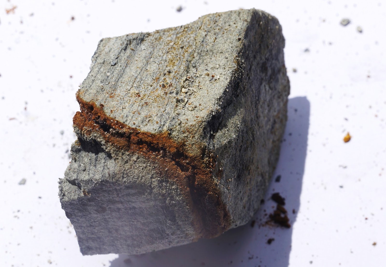
Chaotic and Heterogeneous Sandstone Rock
Three distinct layers across the cross-section, it looks chaotic and heterogeneous.
How to describe such rock?
The rock is mainly Sandstone but probably had been metamorphosed by hot quartz veins which later formed the greenish crystallised tourmaline at the mid-section. The top left side is light grey Sandstone while the bottom right is also mainly sandstone but had been permeated, weathered and stained by brown ferrous solution.
Light Grey Sandstone criss-cross by Quartz Veins
This solid Sandstone core with quartz veins, is moderately strong and found near Betong area, about 13m below ground level. The veins appears to be parallel to each other, dipping at an angle.
Near to the top, vein directions can be opposite, perhaps chaotic. Deterioration seems to occur near to these veins and therefore above this rock core, 12m to 13m depth, the core breaks in many small flat pieces.
Sedimentary Rock and the Climate
This Mudstone has a thin layer of sand, less than 2mm, causing the fracture of otherwise continuous core. Why this thin layer existed during the formation?
Climate played a major role in such formation. Mudstone and Shale were generally former alluvial and shallow sea deposits which later converted to rock due to pressure and temperature. The materials were brought down from highlands through erosion and water flow. Water flow is associated with climate. Along the rivers, plains and sea, there are zones of the various sizes of particles. In general, if the climate is uniform, nearer to the hill will be boulders, cobbles, and gravels. Further downstream, the gradient is lesser and less rapid water flow, the particles are of smaller sizes, sands would be the major constituents. Towards the plains and the lake/sea, water flow is much slower due to flatness and very slow flow, silt and clay will be deposited. But weather is never constant, sometimes you have storm and sometimes drought. That was the time different materials would be deposited at the supposed gravels, sand. silt and clay areas. The mud area obviously experienced a heavy storm which resulted larger particles, the sand, to deposit at the silt/clay site.
Therefore, if we can drill this whole rock formation and study the distribution of particles sizes, we can probably study the climate conditions throughout the depositing period. But dating may be difficult if fossils are not found.
Shale Bedrock
It looks intact at the outside when it was brought up 21m below ground level which was also probably the actual in-situ state, lying deep beneath the Earth.
But during the drilling process which used water plus the vibration of the drilling machine, the Shale deteriorated fast. The core broke into pieces which might not reflect the actual condition beneath.
The longer you drill, the worst the core will be. That is why it is always a good practice to drill short pieces and bring up fast. The use of standard 1.5m length is not good for this type of rock. But Contractor will find this way too time consuming and costly. They prefer the maximum 1.5m. He may not be able to bring up anything (lost core) but it does not mean there is nothing down there, just change into mud slurry with the drilling water.
Soothing Microtonalite Rock
Among all the rocks, this greenish and clean rock gives me the most soothing and pleasing appearance. Perhaps there are some truth that certain crystals can heal people's dampened feelings due to their beauties and dazzling reflections. This rock certainly intrigues me.
It is like looking at this beautiful hot hibiscus, which is one my favourite flowers!
Deeply Weathered Rock
You would think that when the bedrock was buried 30m below theground level, it should be well protected and in nice form.
This photo tells you a different story. The Shale bedrock at 28m to 33m is almost disintegrated especially towards the deeper depth.
Previous blog had shown you why and how water permeated into the rock.
Give these rocks another thousands of years, they will turn into soils, clay/silt with some sand.
Oh, what are those crystallised whitish pieces of rocks embedded in the dark grey Shale rock at 32.5m depth?
These rocks were not from above, i.e. not deposited soils from Earth weathering processes. They were from deep beneath the earth, 10-30 kilometres down from magma layer, who tried to escape to the surface through cracks and small vents, probably million years ago, but lost their steam before reaching the surface and solidified to form quartz seam. They are now weathered into smaller quartz pieces. Quartz is the second most abundant minerals on Earth.
How Weathering of Rock Occurred Deep Beneath the Ground
Water is one of the greatest destructive agents causing the weathering of the rock, even deep beneath the ground.
Water flows from high ground to low ground, which is generally the mean sea level on Earth, due to gravity. In doing so, they will find the shortest path and permeates through any weak spot to reach the destination. Therefore it travels not only on the surface, it also penetrates through the ground and rock. This water often carries impurities and chemical solutions which form evidence of the water path through the rock.
This Sandstone rock sample shows distinct mark cutting through the bedding and is found at 12m below ground level, 3m into the mainly Sandstone bedrock.
Layered Sandstone and Shale Bedrock
Bedding marks show the evidence of the landmass being bent during mountain building with distinct angle of dipping layers. These almost horizontal layered rocks 10.7m to 12.7m below the ground level represent either the crest or the top of the chain of mountain formed. The rocks are mainly light grey SANDSTONE but dark grey SHALE are also found in thin layers. Take note that there is no such thing as homogeneous in the rock as weathering sets in. It is important therefore for Civil Engineers to study and analyse the rock carefully before providing any foundation on it, especially high rise building.
Steel Structures
In London, steel structures are often used for bridges and boat terminals. I admire the authorities who maintain so well!
In our country, steel is not often used due to higher cost and difficult maintenance under humid tropical climate. Rusting is the main problem as can be seen in this steel structure. The structure lost its shine after a while. Painting normally lasts a few years depending on the quality of paints and workmanship. After that, nobody bothers about it until the structure starts to fail.
We do not have a habit to allow cost for maintenance and think that any structure, once built, will last forever!